
Vancouver, BC – March 7, 2024 – Metallis Resources Inc. (TSX-V: MTS; OTCQB: MTLFF) (the “Company” or “Metallis”) today announces results from its recently completed data compilation program (the “Program”) on the newly acquired Greyhound property (the “Property”). The Program included detailed analysis of geological and mining reports along with several recently discovered archived newspaper articles, providing the Company with an improved understanding of both the geology and mineralization along the 3.6 km Greyhound shear/vein. Metallis believes the large number of prospective showings highlighted on the property offer the Company multiple opportunities for the discovery of high-grade gold and silver.
Dave Dupre, Vice President of Exploration for Metallis commented, “Our research program was successful in uncovering over 20 archived newspaper articles about the property from 1895-1905 that had likely never been seen by previous operators. These articles described a significant mining camp on the Greyhound property and mentioned multiple bonanza gold grades with results as high as 35,226 g/t Au and 128,250 g/t Ag from the Bulldog Mine.” He went on to add, “We have also identified that a large amount of the past mining was achieved by driving adits horizontally along the Greyhound shear with no guidance from geological mapping, geophysical surveys, or diamond drilling. Although past operators were still able to return strong grades from historic adits, more recent work on the property has suggested the highest-grade mineralization is oriented vertically and provides opportunity for discovery above and below previously mined areas. The team is excited to apply this new knowledge as we utilize modern exploration techniques for the first time in this property’s history.”
Through use of multiple data sources, Metallis’ technical team has been able to summarize the property’s history and expand on the understanding of each prospective showing. When possible, more recent rock sampling and reporting has been prioritized.
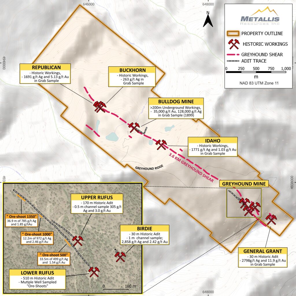
Greyhound Mine
Exploration at the Greyhound Mine began in the late 1800’s with the Upper Rufus Adit being driven into high grade silver/gold/lead/zinc shear veins discovered on Sulfur Creek. This adit was driven into the south side of Greyhound Ridge for approximately 170 m and provided material for the Greyhound smelter (stamp mill) erected in 1905 that also received material from numerous other showings across the property. Mining ceased and the smelter eventually was abandoned in 1910 with the collapse of silver prices.
In 1979, Greyhound Mining and Milling (the current claim owners) began excavating the Lower Rufus Adit, located 140 m southeast of the Upper Rufus portal. This new adit was driven 300 m with material being transported to a mill offsite. It was further extended 152m between 1980 -1991 and intercepted strong zones of high-grade mineralization. A final shipment of material was sent in the year 2000.
More recent property examinations have detailed several sampling programs in the Lower Rufus Adit with the most thorough data being derived from Hornbaker (1988). A total of 17 channel samples were collected from footage 1331 to 1406 across the vein and demonstrated very robust high-grade mineralization along a total length of 22.9m. This interval returned an average grade (using a minimum width of 5 feet) of 0.06 oz/t Au and 26.38 oz/t Ag (2.05 g/t Au and 902 g/t Ag)*.
These high-grade sections have been referenced in historic reports as “ore-shoots” and represent the highest-grade zones returned in the Lower Rufus Adit (see table below). These tabular bodies are vertically oriented, and it is likely that past miners were unable to fully exploit them with horizontal adits. It is also important to highlight that moderate grade mineralization occurs along the entire length of the Lower Rufus Adit and is not restricted to these ore-shoots.
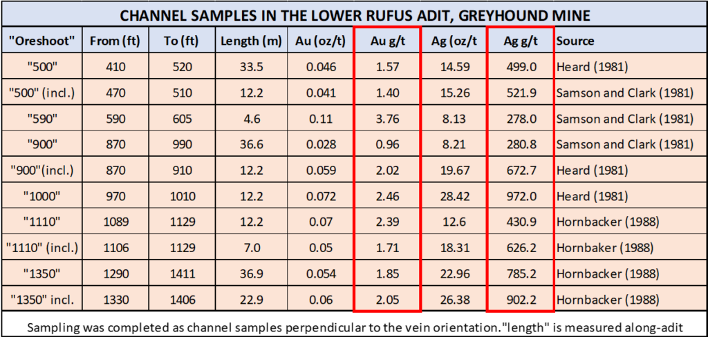
Note: The term “oreshoot” is used in this news release to describe a segment of a mineralized shear/vein which has a grade and width which might be economic. But, as no economic studies have been performed, there is no intension to imply that the material within an “oreshoot” will necessarily constitute “ore”.
Bulldog Mine
The Bulldog mine, located on the north side of Greyhound Ridge, operated from 1898 to 1906, with several surface and underground workings being completed. A historic adit measuring ~152 m in length was driven southeast, along strike within the Greyhound shear/vein with a ~60m crosscut also completed.
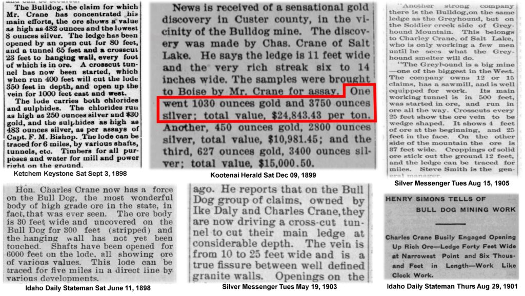
During historic data compilation, the Metallis team discovered 20+ old newspaper articles dating from 1898 to 1905 that referenced extremely high grades at the Bulldog Mine. One article mentioned a rock sample from a 6 to 14 inch wide vein, that carried “1,030 oz/t gold and 3750 oz/t silver*” (35,226 g/t Au and 128,250 g/t Ag). This information is historical, albeit from numerous sources, with two other samples displaying bonanza results. While the Metallis technical team regards 100+ year old newspaper articles as highly speculative, they are encouraged by the prospect of very high gold grades on the Property and look forward to commencing their own exploration efforts.
Further reporting by the Idaho Bureau of Mines and Geology (IBMG) suggests that high gold grades exist at the Bulldog, something not identified in later reporting. The IBMG, in a publication from 1920 states, “Ore from this vein, it is maintained, runs about $11 to the ton in gold, and 30 ounces of silver”. Converted to today’s values, that would be 18.2 g/t Au and 1026 g/t Ag.
More recent historic sampling at the Bulldog has been restricted to single day visits with rock samples taken from trenches or waste piles. These rocks have returned elevated assays of 10-20 oz/t silver and grab samples as high as 69 oz/t silver. Descriptions of the surface showing detail a 10m thick shear zone with two high grade veins separated by lower grade material, as well as elevated base metals and bornite mineralization (Kershner, 1976). In 1980, approximately 12,000 tons of material was removed from this location although there is no documentation of any results, and it is possible this was from historically stockpiled material.
Birdie
The Birdie Showing represents a parallel shear vein 125 m to the east of the Greyhound Shear. Minor production in the late 1800’s is noted in historic reports that document approximately 100 feet (30 m) of workings being driven into Greyhound Ridge. A newspaper article from 1894 reported silver grades of 216 oz/t (7,387g/t)*. Work completed by Watts-Griffis-McQuat in 1981 highlighted a 3-foot chip sample just inside the portal that returned 2.42 g/t Au and 2,858 g/t Ag*. The adit has since collapsed, and the full extent of the vein is unknown in this area.
General Grant
The General Grant portal is situated 400 m southeast of the Lower Rufus. The 30 m adit supplied material to the Greyhound mill built on site in the early 1900’s. No recent exploration has been completed near the adit although a bulldozer cut located approximately 100 m northwest along strike of the portal is highlighted by a 2.4 m section of 2.56 g/t Au and 366 g/t Ag*. In 1980, Noranda collected a sample from the bulldozer cut that ran 11.9 g/t Au and 2,798g/t Ag*.
Idaho
The Idaho showing occurs centrally along the Greyhound shear between the Bulldog and the Greyhound Mine. Little information is available from this location although historic reporting from the early 1900’s suggests a pit was excavated and more recent grab samples by Lance (1999) returned 1.03 g/t Au and 1,771 g/t Ag *.
Buckhorn
The Buckhorn Showing is located near the Northwest end of the Greyhound shear zone approximately 650m northwest of the Bulldog Mine and 3000 m northwest of the Greyhound Mine. This showing was worked in the early 1900’s and included a small shaft although little information is available. A single rock sample taken by Kershner (1976) returned 263 g/t Ag*.
Republican
The Republican showing is the most northwesterly historic working completed along the Greyhound shear. This showing was worked in the early 1900’s with minor historic workings still visable. Lance (1999) describes a single grab sample taken from a dump pile that returned 5.13 g/t Au and 1,691 g/t Ag*.
*All grades mentioned in this release are historical in nature and can not be verified by Metallis Resources
Qualified Person
David Dupre, P.Geo, Vice President – Exploration and the Qualified Person, as defined by National Instrument 43-101, has reviewed and approved the technical information contained in this release.
About the Greyhound Property
The recently acquired Greyhound Property is in Custer County, Idaho, approximately 42 km northwest of the town of Stanley. This property was the center of an active silver mining camp in the early 1900’s and at one point contained a smelter and two active mines situated along a 3.6 km mineralized shear zone. Since 1910, the property has seen limited exploration and only minor development when the Greyhound Mine was reactivated and mined from 1980-1991. The last remaining ore from this period was shipped to a smelter in 2000 and the property remains substantially underexplored.
About Metallis
Metallis Resources Inc. is a Vancouver-based company focused on the exploration for gold, copper and silver on its flagship 100%-owned Kirkham Property in Canada, situated in northwest British Columbia’s Golden Triangle, and on its recently acquired Greyhound Property, a gold/silver target in Idaho, USA.
Metallis trades under the symbols MTS on the TSX Venture Exchange, MTLFF on the OTCQB Exchange, and 0CVM on the Frankfurt Stock Exchange.
Bibliography:
Heard, R.T. 1981.,
Geoogical Report on the Greyhound Mining and Milling Property For Eastern Leaseholds Inc.
Kershner & Mashnurn, 1976.,
Reconnaissance Report on the Bulldog Claim Group for Kershner & Mashburn, Consulting Engineers, Boise, Idaho
Lance, D.L. 1999.,
Geological report on the Greyhound Mine, Custer County, Idaho. For United Silver Inc.
Sampson, T, & Clark, M, 1981,
Geological Report on the Greyhound Mine Custer County, Idaho. Watts, Griffis and McQuat, Incorporated Mining and Geological Consultants
Longe, R. 1999.
A Summary Report on the Greyhound Mine, for Helio Capital Corp, Minequest Exploration Associates Ltd.
On behalf of the Board of Directors:
/s/ “Fiore Aliperti”
Chief Executive Officer, President, and Director
For further information:
Tel: 604-688-5077
Email: info@metallisresources.com
Web: www.metallisresources.com
CAUTION REGARDING FORWARD-LOOKING STATEMENTS
This Press Release may contain statements which constitute ‘forward-looking’ statements, including statements regarding the plans, intentions, beliefs and current expectations of the Company, its directors, or its officers with respect to the future business activities and operating performance of the Company. The words “may”, “would”, “could”, “will”, “intend”, “plan”, “anticipate”, “believe”, “estimate”, “expect” and similar expressions, as they relate to the Company, or its management, are intended to identify such forward-looking statements. Investors are cautioned that any such forward-looking statements are not guarantees of future business activities or performance and involve risks and uncertainties, and that the Company’s future business activities may differ materially from those in the forward-looking statements because of numerous factors. Such risks, uncertainties and factors are described in the periodic filings with the Canadian securities’ regulatory authorities, including quarterly and annual Management’s Discussion and Analysis, which may be viewed on SEDAR at www.sedarplus.ca. Should one or more of these risks or uncertainties materialize, or should assumptions underlying the forward-looking statements prove incorrect, actual results may vary materially from those described herein as intended, planned, anticipated, believed, estimated, or expected.
Although the Company has attempted to identify important risks, uncertainties and factors which could cause actual results to differ materially, there may be others that cause results not to be as intended, planned, anticipated, believed, estimated, or expected. The Company does not intend, and does not assume any obligation, to update these forward-looking statements.
Neither TSX Venture Exchange nor its Regulation Services Provider (as that term is defined in policies of the TSX Venture Exchange) accepts responsibility for the adequacy or accuracy of this release. The TSX-V Stock Exchange has neither approved nor disapproved the contents of this news release.