
February 1, 2022
Vancouver, BC: Metallis Resources Inc. (TSX-V: MTS; OTCQB: MTLFF; FSE: 0CVM) (the “Company” or “Metallis”) is pleased to announce the results from its 2021 drill program (the “Program”) at its 100%-owned Kirkham Property (the “Property”) situated in the heart of prolific Eskay mining camp of the Golden Triangle in northwestern British Columbia. The Eskay mining camp is well-known for its diverse metallogeny highlighted by the past producing Eskay Creek and Snip gold mines, Seabridge’s KSM porphyry deposits and Pretium’s Brucejack gold mine, which has recently been sold to Newcrest Mining Ltd. for $3.5 billion.
Fiore Aliperti, Metallis’ President and CEO stated, “Results from the 2021 program are the leap forward we were looking for and provide a fundamental breakthrough in the geological model representing the Cliff-Miles Porphyry Corridor. Most importantly, significant progress has been made by our team in defining a substantial gold system sitting near surface at the Cliff-Miles Porphyry Corridor. This improved understanding has led the technical team to model a significant 600 meter deep, half-graben structure which features a silicified, gold-rich sub-vertical feeder zone along the Adam Fault with laterally extensive, semi-conformable, gold-bearing branches which now expands the corridor even further to the east than previously thought.”
Program Summary and Highlights
The Program consisted of 7 deep drill holes comprising a total of 4,785 meters (“m”). The holes were designed to expand the large, 2 km long mineralized Cliff-Miles porphyry system. Specifically, the Program targeted the cluster of Induced Polarization (“IP”) anomalies and the depth potential of the mineralization. (See News Release September 8, 2020). Significantly, all drill holes intersected long intervals of well mineralized porphyritic monzonite and a succession of silicified siliciclastic rocks carrying high-grade gold (See Table-1 below).
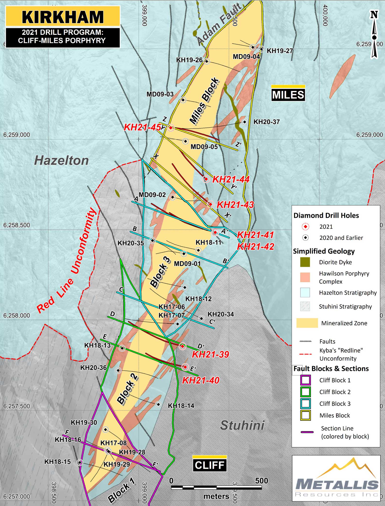
Intercepts of high-grade gold mineralization constrained within stockwork fractured porphyry intrusions and host rocks were encountered (e.g., KH21-45 returned 1.05 g/t AuEq over 43 m from surface). The geological interpretation helped identify a new model of the Cliff-Miles porphyry system sitting within a fault-bounded half-graben structure with multiple sub-blocks (Click to view plan map). The graben structure is attributed to the extensional tectonics in the Golden Triangle – responsible for hosting some of the well-known porphyry and epithermal gold deposits such as the world-renowned KSM porphyry cluster and Valley of the Kings gold deposit (Board et al., 2020). The down-dropped block within the half-graben is made up of volcanoclastic, flows and limestones belonging to the Hazelton Group. The fertile Texas Creek monzonite stocks intrude this pile and bring the mineralized hydrothermal fluids. The mineralization in each block is represented by a sub-vertical feeder (or “Trunk”) zone and laterally extensive branches hosted within a gently east-dipping stratigraphy. Refer to cross sections linked below.
Dave Dupre, VP of Exploration remarked, “Guided by the classic zonal model, our initial objective of the 2021 program was to test for improved porphyry copper/gold grades at depth. Midway through the program, the geological team pivoted their focus to the gold rich overprinted siliceous zones. This led to the impressive results obtained from drill hole KH21-45.” He went on to add, “We are extremely pleased with the successful application of our new geological model which shows four Cliff-Miles structural sub-blocks and an eastward expansion of the near surface gold mineralization. Work is currently underway to advance our understanding and evaluation of the individual blocks for their vertical and lateral expansion this coming season”.
The siliceous gold zones display remarkable continuity. The gold zone at the Miles sub-block is ~150 m wide, at least 1,000 m long and 600 m deep. It is open along strike and down-dip. The Miles sub-block shows broad zones of gold-rich mineralization highlighted by:
- KH21-45 with 0.43 AuEq over 220.7 m – from surface
- Incl. 1.05 g/t AuEq over 43.0 m – from surface
- KH20-37 with 0.42 g/t AuEq over 175.0 m – 400 m below surface
- Incl. 1.24 g/t AuEq over 32 m – 400 m below surface
- MD09-05 with 0.36 g/t AuEq over 86.5 m – 200 m below surface
Significant drill intersections from the 2021 drill program are presented below (Table 1), and all the Cliff-Miles holes are included on the website. (Click Here to View Full Composite Table).
Table 1
| Hole_ID | From (m) | To (m) | Length (m) | AuEq* (g/t) | Au (g/t) | Cu (%) | Ag (g/t) | Mo (ppm) |
| KH21-39 | 231.80 | 316.70 | 84.90 | 0.27 | 0.13 | 0.10 | 0.76 | 17.45 |
| 414.00 | 444.80 | 30.80 | 0.24 | 0.15 | 0.06 | 0.29 | 22.13 | |
| KH21-40 | 181.40 | 235.00 | 53.60 | 0.24 | 0.21 | 0.02 | 0.49 | 13.35 |
| 374.75 | 552.00 | 177.25 | 0.34 | 0.29 | 0.02 | 0.96 | 16.43 | |
| incl. | 374.75 | 396.85 | 22.10 | 0.49 | 0.47 | 0.01 | 0.31 | 3.70 |
| incl. | 519.60 | 552.00 | 32.40 | 0.82 | 0.78 | 0.01 | 1.64 | 2.10 |
| KH21-41 | 51.10 | 375.00 | 323.90 | 0.24 | 0.14 | 0.07 | 0.45 | 38.09 |
| incl. | 51.10 | 96.30 | 45.20 | 0.36 | 0.31 | 0.03 | 0.89 | 24.63 |
| KH21-42 | 78.00 | 169.50 | 91.50 | 0.38 | 0.33 | 0.03 | 0.38 | 17.05 |
| incl. | 78.00 | 108.00 | 30.00 | 0.63 | 0.60 | 0.02 | 0.22 | 10.98 |
| 436.00 | 644.00 | 208.00 | 0.36 | 0.18 | 0.13 | 0.93 | 38.27 | |
| incl. | 451.00 | 565.60 | 114.60 | 0.38 | 0.18 | 0.15 | 0.98 | 33.28 |
| KH21-43 | 79.10 | 254.80 | 175.70 | 0.23 | 0.17 | 0.04 | 0.37 | 27.28 |
| incl. | 79.10 | 119.80 | 40.70 | 0.55 | 0.51 | 0.03 | 0.38 | 16.31 |
| 584.00 | 660.00 | 76.00 | 0.30 | 0.27 | 0.01 | 0.20 | 8.73 | |
| incl. | 584.00 | 589.60 | 5.60 | 4.01 | 3.69 | 0.20 | 2.75 | 118.53 |
| KH21-44 | 77.00 | 423.70 | 346.70 | 0.25 | 0.13 | 0.08 | 0.69 | 31.85 |
| KH21-45 | 5.30 | 226.00 | 220.70 | 0.43 | 0.34 | 0.06 | 0.90 | 19.19 |
| incl. | 5.30 | 63.00 | 57.70 | 0.78 | 0.74 | 0.02 | 1.60 | 6.76 |
| Incl. | 8.00 | 51.00 | 43.00 | 1.05 | 1.00 | 0.02 | 2.14 | 9.07 |
| 358.00 | 504.00 | 146.00 | 0.30 | 0.24 | 0.04 | 0.48 | 11.66 |
*Gold equivalent grades (‘AuEq.”) are for comparative purposes only. Calculations are uncut and recovery is assumed to be 100% as no metallurgical data are available. The metal prices including: US$1700/oz Gold, US$20/oz Silver, US$3.0/lb. Copper & $9.0/lb. Mo. were used for (AuEq g/t). Drilling data to date is insufficient to determine true width of the mineralized zone. Composites are determined using a notional 0.20 g/t AuEq cut-off, a maximum of ten meters of internal dilution for porphyry-style mineralization and no top cut is applied.
Cliff-Miles Porphyry Corridor Geology:
For the first time, the Company drilled three oriented core holes which are used to help measure directional properties in rock and is routinely utilized to measure features such as bedding, fractures, and veins. This technique helped the Company constrain the geometries of the faults, porphyry intrusions and lithostratigraphic units. The latest 3D modeling and interpretation of the 2021 drilling assays have revealed that the overprinted gold mineralization discovered near surface offers significant upside potential for the Company and future exploration programs.
The entire 4 km-long Cliff-Miles porphyry corridor is now divided into 4 sub-blocks characterized by similar patterns of alteration and mineralization all along the plutonic rocks and east-dipping Hazelton Group rocks. The feeder (trunk) zone to the west and multiple horizons of gold-rich mineralization are constrained along the early medium porphyry (“MP”) dikes and sills. The late-mineral porphyry (“CP”) exists as a singular dike on the Western-most margin of the system; however, KH21-40 and previous drill holes intersected a second CP dike on the East, suggesting the presence of additional well-mineralized porphyry dikes and sills to the East and at depth.
Miles Block
The northernmost Miles Block is identified as a half-graben structure where drill hole KH21-45 cut a substantial intercept of gold-rich mineralization highlighted by 220.7 m of 0.43 g/t AuEq including 43 m of 1.05 g/t AuEq. (Click to View Miles Block Cross Sections). The gold-rich mineralization in KH21-45 is associated with highly silicified limey siltstone, sandstone and stockwork fractured porphyry intrusions confirming a 600 m vertical extent of the gold zone, discovered in KH20-37, which returned 1.21 g/t Au over 32 m within a broader intercept of 0.68 g/t Au over 83 m. (See News Release February 10th, 2021). The gold zone at this block is ~150 m wide and remains open to the north for another 500 m where historic drill holes and trench samples assayed 0.5 to 2.5 g/t Au confirming the vertical and lateral continuation of the gold zone to be tested in follow-up programs.
Block-3
The porphyry intrusions in the central Block-3 were emplaced along the curviplanar Adam Fault to the west. The later epithermal gold overprint (characterized by 0.49 g/t AuEq over 22.1 m in KH21-40 and 0.63 g/t AuEq over 30.0 m in KH21-42) is associated with the syn-mineral faults and bedding-parallel permeability in the east-dipping Hazelton Group host rocks. KH21-42 intersected the deepest known Quartz A-Vein stockwork mineralization to date, running 0.36 g/t AuEq over 208.0 m, and leaves it open to depth, along strike to the south and southwest where drill hole KH20-34 intersected 1.13 g/t AuEq* over 54 m within a broader interval of 0.64 g/t AuEq over 141 m (Click to View Block 3 Cross Sections).
Block-2
Block-2 is expanded to the east where KH21-39 and KH21-40 drilled broad intercepts of gold mineralization including 84.9 m of 0.27 g/t AuEq and 177.25 m of 0.34 g/t AuEq respectively. Both holes intersected multiple sub-parallel porphyry sills varying in thickness from meters to hundreds of meters extending eastward from their feeder dykes. The feeder dykes to the west are represented by typical porphyry style mineralization as intersected in KH20-36, which returned 490.8 m of 0.33 g/t AuEq, including a 56 m zone of 0.50 g/t AuEq. (Click to View Block 2 Cross Sections).
Block-1
Block-1 defines the southern tip of the graben structure truncated by an east-west sinistral fault. This block is dominated by multiple crosscutting Coarse-Porphyry (“CP”) and Medium-Porphyry (“MP”) dikes characterized by relatively higher-grade copper-gold mineralization. The best intercepts reported from this block (i.e., 115.0 m of 0.81 g/t AuEq in KH18-16 and 90.0 m of 0.80 g/t AuEq in KH17-08) are from within the Medium-Porphyry (“MP”) stock which remains open at depth and along strike (Click to View Block 1 Cross Section).
Future Exploration Plans
The very encouraging 2021 results has led to a ramped-up exploration plan for 2022. Early-stage planning envisages an extensive program of closely spaced holes to define the near surface gold targets and simultaneously evaluate the high-grade porphyry copper-gold targets at depth.
Building on the assay results and latest 3D modeling, Metallis’ technical team is currently evaluating the morphology and distribution of the well-mineralized bodies in each structural block. The on-going 3D Voxel modeling of the IP and ZTEM resistivity anomalies is being used to help with generating additional drill targets focused on the depth potential of the porphyry system, already tested down 600 m from surface.
QAQC and Analytical Protocols
Metallis has implemented a rigorous quality assurance / quality control (QA/QC) program to ensure best practices in sampling and analysis of diamond drill core and surface rocks and soils. The drilling samples including 1-3 m intervals of HQ and NQ drill core were delivered to ALS Global prep facilities in Terrace and Langley BC, where the samples were crushed to 70% pass 2mm fraction, and then a 250g split was pulverized to better than 85% passed a 75-micros screen. The geochemical analyses were performed by ALS Global in Vancouver using multi-element 4-Acid digest ICP-MS package (ME-MS61). Gold was analyzed by fire assay technique Au-ICP21. Gold grades ≥10 g/t were analyzed by fire assay and gravimetric finish. In addition to the internal QAQC program by ALS, Metallis inserted 10% lab certified standards, field blanks and duplicates into the overall sampling stream.
ALS is a global testing, inspection and certification business and is an ISO/IEC 17025:2005 accredited laboratory independent of the Company.
Qualified Person
David Dupre, P. Geo, Vice President – Exploration and the Qualified Person, as defined by National Instrument 43-101, has reviewed, and approved the technical information contained in this release.
About the Kirkham Property
The wholly owned 106 sq. km Kirkham Property is located about 65 km north of Stewart, B.C., in the heart of the Golden Triangle’s prolific Eskay Camp. The Property is prospective for multiple mineral deposit types and is located along a strategic geological boundary – the “Red-line” exposed on the western margin of the Eskay Rift system in the Golden Triangle, northwestern British Columbia.
The Kirkham Property is contiguous to Garibaldi Resources Corp.’s E&L Nickel Mountain Project in the north and Eskay Mining Corp. to the east. The property is within 12 km of the Eskay Creek mine and within 12 – 20 km of Seabridge Gold’s KSM deposits and Newcrest Mining’s newly acquired Brucejack mine.
About Metallis
Metallis Resources Inc. is a Vancouver-based company focused on the exploration of gold, copper, nickel, and silver at its 100%-owned Kirkham Property situated in northwest British Columbia’s Golden Triangle region. Metallis trades under the symbols MTS on the TSX Venture Exchange, MTLFF on the OTCQB Exchange, and 0CVM on the Frankfurt Stock Exchange. The Company currently has 52,839,878 common shares issued and outstanding.
On behalf of the Board of Directors:
/s/ “Fiore Aliperti”
Chief Executive Officer, President and Director
For further information:
Tel: 604-688-5077
Email: info@metallisresources.com
Web: www.metallisresources.com
CAUTION REGARDING FORWARD-LOOKING STATEMENTS
This Press Release may contain statements which constitute ‘forward-looking’ statements, including statements regarding the plans, intentions, beliefs and current expectations of the Company, its directors, or its officers with respect to the future business activities and operating performance of the Company. The words “may”, “would”, “could”, “will”, “intend”, “plan”, “anticipate”, “believe”, “estimate”, “expect” and similar expressions, as they relate to the Company, or its management, are intended to identify such forward-looking statements. Investors are cautioned that any such forward-looking statements are not guarantees of future business activities or performance and involve risks and uncertainties, and that the Company’s future business activities may differ materially from those in the forward-looking statements because of numerous factors. Such risks, uncertainties and factors are described in the periodic filings with the Canadian securities’ regulatory authorities, including quarterly and annual Management’s Discussion and Analysis, which may be viewed on SEDAR at www.sedar.com. Should one or more of these risks or uncertainties materialize, or should assumptions underlying the forward-looking statements prove incorrect, actual results may vary materially from those described herein as intended, planned, anticipated, believed, estimated, or expected.
Although the Company has attempted to identify important risks, uncertainties and factors which could cause actual results to differ materially, there may be others that cause results not to be as intended, planned, anticipated, believed, estimated, or expected. The Company does not intend, and does not assume any obligation, to update these forward-looking statements.
Neither TSX Venture Exchange nor its Regulation Services Provider (as that term is defined in policies of the TSX Venture Exchange) accepts responsibility for the adequacy or accuracy of this release. The TSX-V Stock Exchange has neither approved nor disapproved the contents of this news release.